Chicago area under severe thunderstorm warning as dangerous storms approach
A line of severe thunderstorms poses significant threats to the Chicago metropolitan area Wednesday afternoon, July 16, prompting officials to issue multiple weather warnings across the region.
Severe thunderstorm warning details for Chicago counties
A Severe Thunderstorm Warning is in effect for Will County until 3:45 p.m.; Grundy, DuPage, Kane and LaSalle counties until 4 p.m.; and Cook County until 4:15 p.m.
Also read: The future of weather prediction is here. Maybe.
A Severe Thunderstorm Watch has been issued for Boone, Cook, DuPage, Grundy, DeKalb, Kane, Kendall, Kankakee, LaSalle, Lake, McHenry and Will counties in Illinois and Lake, Jasper, Newton and Porter counties in Indiana until 8 p.m.
Chicago airports implement ground stops due to severe weather
There is a ground stop at Chicago O’Hare and Chicago Midway airports due to the storms, FAA officials said. The duration of the stop is not known. O’Hare is also reporting ground delays averaging about two hours due to the storms.
Winds gusts up to 45 miles per hour have been recorded at both O’Hare and Midway.
Storm timeline and movement across Chicago region
Storms developed west of Chicago and raced east before slowing down a little over the western suburbs to about 35 miles per hour. By 3:30 p.m. the front edge of the line of storms had arrived in the west and southwest suburbs. They are expected to reach the city shortly before 4 p.m. before moving onto Northwest Indiana. Storms are expected to be out of Northwest Indiana by about 7:30 p.m.
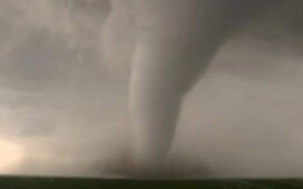
Hail, wind damage, and tornado risk forecast for Chicago area
The storms could bring hail up to one inch in diameter and wind gusts up to 79 miles per hour. There is also a risk for tornadoes developing, which while low is also not zero.

The majority of the Chicago area is under a level two “slight” risk of severe weather.
Flooding risk lower than previous Chicago storms
While the storms are expected to bring heavy downpours, they’re also expected to move through the Chicago area much quicker than last week’s storms that caused flash flooding on the West Side. As such, there is less of a flooding risk Wednesday evening but a greater chance of wind damage from strong, gusty winds.
Temperature drop expected after Chicago storms pass
Temperatures Wednesday will reach the 90s with noticeable humidity, driving real feel up towards 100 degrees. The storms will drop those temperatures drastically by about 20 degrees, with forecasted highs for Thursday only in the low 70s and cooler than we’ve seen in more than a month. In some lakefront communities, Thursday highs may not even reach 70.
Beach hazard statement issued for Chicago lakefront
The onshore winds keeping temperatures cool will also produce dangerous swimming and boating conditions; a Beach Hazard Statement is expected on Thursday into Friday.