September 9, 2024
3 min read
Brewing Hurricane Francine Heads toward Louisiana, Ending Atlantic Hurricane Lull
Tropical Storm Francine formed on Monday, ending a lull in the Atlantic hurricane season. It is expected to hit Louisiana as a hurricane

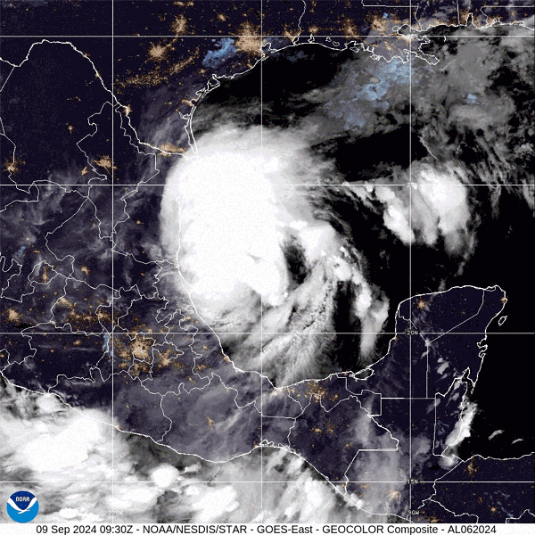
Tropical Storm Francine as it formed over the Gulf of Mexico on Sept. 9, 2024.
The weeks of eerie quiet in the Atlantic ocean basin have come to an end: Tropical Storm Francine formed in the Gulf of Mexico on Monday morning and is expected to hit Louisiana on Wednesday evening. Forecasters are warning of a life-threatening storm surge and up to a foot of rain in some spots.
Francine is the first Atlantic storm since Ernesto dissipated on August 21, at the beginning of what is typically the peak of the region’s hurricane season activity. Forecasters aren’t sure what has kept a lid on storm formation, especially given that ocean waters—the fuel for hurricanes—have been exceptionally warm. It could be some combination of Saharan dust that is blowing off the western coast of Africa—and keeping the atmosphere too dry for moisture-loving tropical systems—and a shift in a wind pattern over the continent that is leading to fewer of the atmospheric disturbances that often act as hurricane seeds.
Whatever caused the lull, it’s over for now. On Monday afternoon Francine was still getting itself more organized, but forecasters expected the storm to intensify into a Category 1 hurricane by later on Tuesday and to become a Category 2 by Wednesday as it passed over very warm waters before making its landfall somewhere along the Louisiana coast.
On supporting science journalism
If you’re enjoying this article, consider supporting our award-winning journalism by subscribing. By purchasing a subscription you are helping to ensure the future of impactful stories about the discoveries and ideas shaping our world today.
The National Hurricane Center’s forecast says there is some chance for rapid intensification, when a storm’s sustained winds jump by at least 35 miles per hour in 24 hours. Hurricane Beryl, which became the earliest Category 5 storm on record in the Atlantic basin earlier this season, had its winds increase by 63 mph in a single day.
“It doesn’t take long,” says Shawn O’Neil, a meteorologist at the NWS’s office in New Orleans. This is “one of the reasons we always tell people to prepare for a category higher” than the forecast.
Several studies have found that more storms will undergo rapid intensification, and will do so at faster rates, as the climate warms because of the burning of fossil fuels.
The current forecast track has the center of the storm making landfall along Louisiana’s central coast, but there is still significant uncertainty. Depending on how the storm interacts with a high-pressure ridge in the eastern Gulf of Mexico and a cold front along the northern Gulf Coast, the storm could veer east or west.
The worst storm surge and rain are expected along the eastern side of the storm, and there is some chance it will spawn tornadoes. The highest storm surge estimates are for five to 10 feet, from Cameron, La., to Port Fourchon, La. Rainfall estimates are for four to eight inches, with some spots seeing up to a foot. There is substantial chance of flooding from both the rain and surge, particularly because the ground is already saturated after recent rains.
Because the storm is approaching from the southwest, O’Neil says, the winds aren’t as conducive to funneling a storm surge into canals and then northward toward New Orleans—which is what happened to the city during the massively disastrous Hurricane Katrina in August 2005.
The central portions of Louisiana’s coast are currently expected to bear the brunt of Francine, and many of those areas are still recovering from previous storms—particularly Hurricanes Laura and Ida, which struck in 2020 and 2021, respectively. Across affected states, the former knocked out power for weeks, did billions of dollars in damage and killed more than 40 people. And Ida killed more than 90 people and knocked out power and water. It is much harder for communities to absorb the blow of a new disaster while they’re still trying to recover from previous ones, according to a report released earlier this year by the U.S. National Academies of Sciences, Engineering, and Medicine. And the odds of having repeated or compound disasters are rising as climate change makes heavy rains, heat waves and drought more common and more intense.
“The years 2020 and 2021 were devastating for the Gulf Coast region,” said Lauren Alexander Augustine, executive director of the National Academies’ Gulf Research Program, which funded the study, in a statement when the report was released. “Our best science tells us that this likely wasn’t a fluke, and we need to draw upon the lessons and experiences of those years to position ourselves to build a strong foundation fitting the new normal of disasters that the 21st century will bring.”